1892: The Fox Farm House at Fox’s Corner, Where Foxes Ran in Foxhurst, Bronx » HoeMap1888
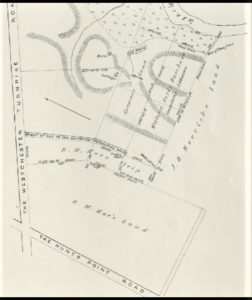
Here’s another old map (about 1888) of Richard Hoe’s land (back then, Southern Boulevard was part of the Hunt Point’s Road, which is now called Hunts Point Avenue).
Here’s another old map (about 1888) of Richard Hoe’s land (back then, Southern Boulevard was part of the Hunt Point’s Road, which is now called Hunts Point Avenue).


